A “How-To” guide to leaving or getting to Villa O’Higgins through Paso Mayer
Foreword: I usually never write about my routes because I find VERY boring blog posts that say: I got up at X hour, pedalled for X Km, stopped for lunch here, water supply there. However, I’m gonna write about a route that might offer an alternative way out (or in) from Villa O’Higgins other than the $50 boat ride. The data on this route is scarce and there is lot of misleading information out there. Boat owners in Villa O’Higgins prefer to scare people away from Paso Mayer for obvious reasons.
Every year a plethora of bikepacking and bike touring aficionados hit Patagonia. In particular two roads that are more popular than others with an aura of myth: Carretera Austral in Chile and Ruta 40 in Argentina; once dirt roads, they are quickly getting paved left and right.
Most people ride north to south hence start the Carretera Austral in Puerto Montt and end in Villa O’Higgins. There’s one main option to leave Villa O’Higgins and cross into Argentina: a boat ride (possibly two) through the lake.
This year the main boat is broken and at times there is a bottleneck of 60-70 people (with respective bikes) waiting up to a week or more to hop into a small 14-person boat that takes them to the other side. The small boat has one major weakness: for safety reasons, it can’t run when it gets windy. However Patagonian winds are globally (in)famous hence boat rides can be few and far between.
This is the reason I investigated a different route to leave Villa O’Higgins.
While the village is about a hundred years old, Carretera Austral was completed only 18 years ago. People used to travel by horse for a few days on two routes to get to Villa O’Higgins. One connects the village with Argentina and the Ruta 40 that allows you to continue the journey to southern Patagonia.
The route leaves from Villa O’Higgins and climbs up to Paso Mayer where there is the Chilean/Argentinian border. It is an official border crossing open all year around and you will be able to stamp out and stamp in in both directions however there isn’t a road that officially connects the two places. There is a single track (sometimes is a double track) you can follow but at times it is lost. You also must cross a few creeks and two rivers.
Apparently 4×4 vehicles can try going across the border during the winter but during summer months the rivers and creeks grow due to ice melting and it’s impossible for them to travel.
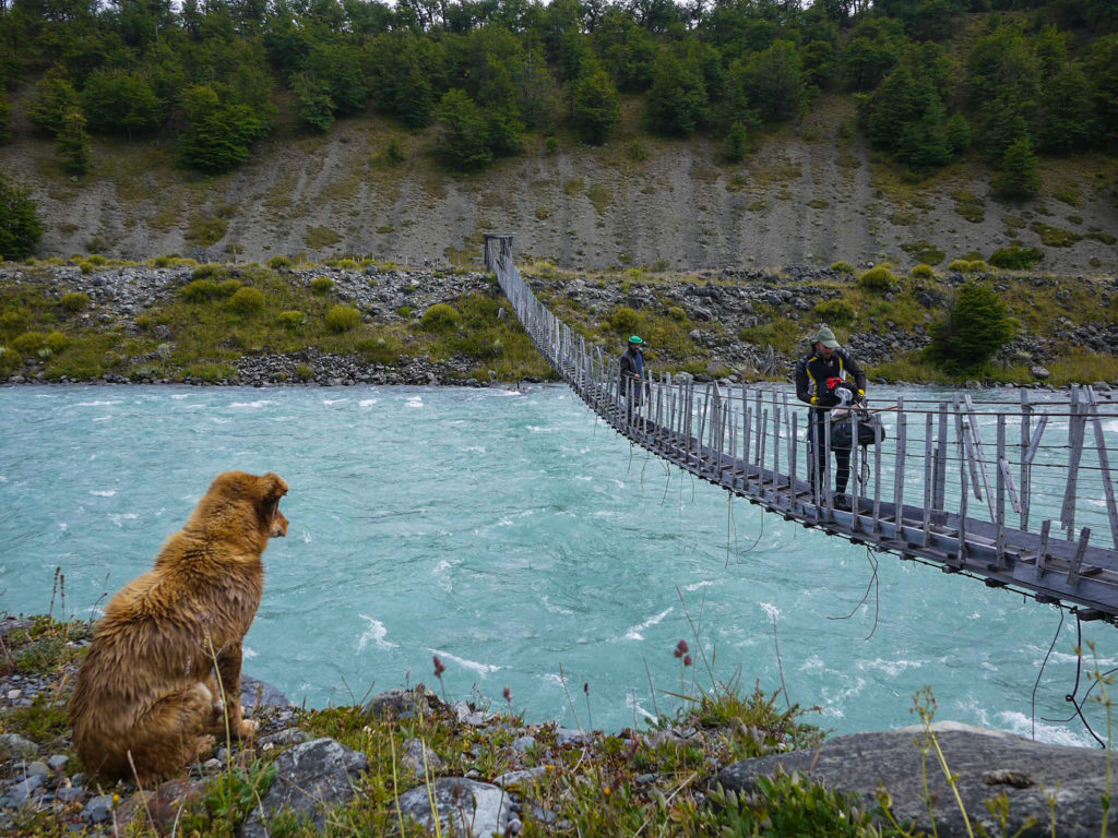
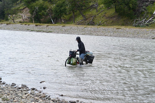
Bikes can cross all year around if you know where to traverse the rivers and creeks because you could find yourself in waist high swamps and the likes. There is also a major river that requires a bridge to get to the other side. Things gets a little tricky here because there isn’t a bridge – however, an estancia (large farm property) built a bridge to get sheep across. The bridge is suspended and in good condition but very narrow, so you will need to remove most of bags and panniers from your bike and if your handle bar is larger than say 46cm you will need untie it and turn it sideways to successfully get the bike on the other side.
You will go through private property, but the Chilean and Argentinian officials assure me there is a right of way. You will find a few gates that are closed without locks but with a log leverage system that once you open the first gate you will understand quickly how it works and you will be able to easily close it again behind you. Be respectful of private property; those gates are there just for cattle segregation.
The route can be done in 2-3 days depending the weather conditions and how relaxed your riding style is.
My companions for this adventure were Aidan and Tara (@portlandtopenguins on Instagram) and it turned out to be a highlight of Patagonia both all of us.
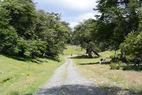
We left Villa O’Higgins late on a sunny morning (January 2nd 2018). You follow the Carretera Austral, a dirt road, for about 7km and then turn right to start climbing up to Paso Mayer. The first 4-5Km are the steepest then it’s gentle climbing with beautiful scenery and plenty of creeks on hand for hydration.
There is a rifugio on the right-hand side before the bridge – you will find it when you still have 1/3 left to get to the top. If the weather is bad you could consider sleeping in there, although there is another rifugio at the top on your left before hitting the Carabinieros to stamp out.
Once you get to the Carabinieros and get your passport stamped out they will show you the river you need to cross. Please notice this is optional as they just completed a road with a new bridge that will take you to the border, simply go back and keep following the road and you will reach the end of it without getting your shoes wet, at least for today. Carabinieros are pretty welcoming but they will try to scare you away from crossing telling you will get lost, that’s all while they will give you a hot cup of tea or coffee. Simply follow my gps tracks and you will be just fine.
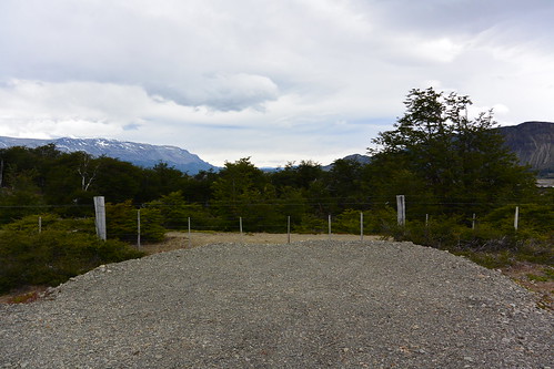
Once you get to the end of the road (see the photo below) the fence you see is the border; on the other side of the fence is Argentina, you can camp here or follow the little doubletrack on the right-hand side and get to the gate of a farm that sits on the border. Just open the gate, close it and get to the little house of Mauche who let us camp there and provided clean water as well as access to the bathroom. He also knows the route to get to Argentinian immigration and he offered to show us the way till the suspended bridge.
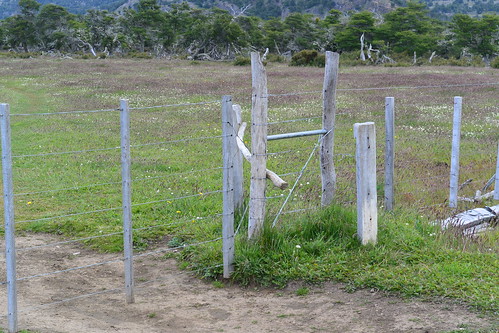
Now the following day we needed to enter Argentina from Mauche’s farm. This is the only part of the route where there isn’t a gate so you need to lift the bottom wire of the fence and slide your bike and belongings under; the top wire is barbed so don’t try the high way!
Once we got ourselves onto Argentinian soil we followed Mauche on his horse (he passed by the river banks) and his dogs leading us to the suspended bridge where we had to remove everything from our bike and slowly cross the river. So, if you follow my gps track it’s like you will have a local guide sorting you through the tricky terrain.
Once crossed, the main river is pretty easy; you just need to be careful where you cross the next creek but it’s nothing too difficult. It will be a single or double track to follow and a few cattle gates to open and close till the Gendarmeria where you will get your passport stamped in Argentina. Expect to find officials in t-shirts and flip flops – they hardly see anyone all year round. We arrived there when they finished baking pizza, so we got two slices of pizza each as a welcoming.
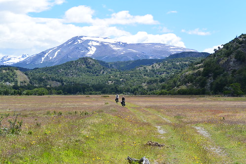
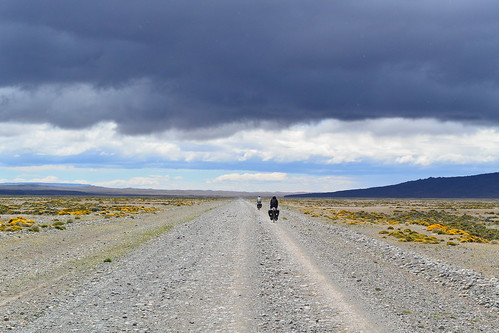
From here to the Ruta 40 the wind will probably be at your back however there is one last river to cross after which you will be dry till hitting Ruta 40. The road is a dirt double track: at times it is sealed and at times it’s not, but overall the conditions are good.
Once you’ve crossed the last river, you will enter a rolling hills wooded area; when you leave it you will get to the Argentinian pampa: flattish and dry land with absolutely no where to shelter yourself from the wind. There are two estancias from here to Ruta 40 where you can ask for some sheltered space to pitch your tent. We were given a room with a stove and wood, so we were able to dry out shoes during the night. Consider loading up with water as the pampa is pretty dry and the river that crosses it doesn’t seem to have the cleanest water.
Once you hit the Ruta 40 (it’s fully paved around here), if you continue south after 3-4Km there is an hotel where you can ask for fresh water. From there to Gobernator Gregorio there is no other point for provisions nor water but there is traffic passing regularly and they are always willing to help you out with water.
Simply follow my gps tracks that you can download here: gpx version or kml version. My only advice is to wear the lightest shoes you have in the morning while you complete all the river crossings and then once you cross the last river after the Gendarmeria, I’d stop and wear dry shoes.
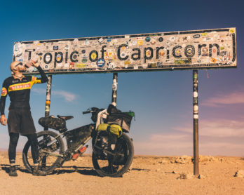
featured photo credits @portlandtopenguins
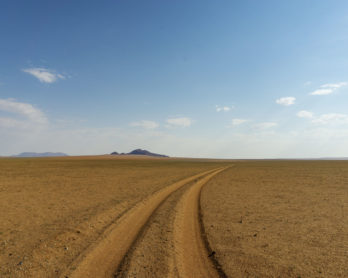
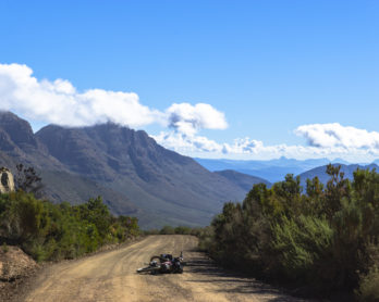
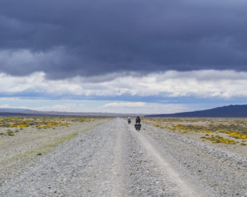
Photo Gallery:


How long did it take for you to get from O’Higgins to El Chalten? What winds situation was in pampa, was wind helping you or resisting?
The hike&bike piece triugh the forest look fine, I am only confused with the rest.
Hey Andrey! If you go though Paso Mayer there isnt really much hike a bike, you should be able to pedal most of it. You get mostly tailswind in the pampa bit till the 40. From the 40 to Gobernatos Gregorious you get tailwind for about 100Km and then is sidewind. From there to El Chialten is probably 60% tailwind 40% headwind/sidewind. It will take you 4/5 days to get to El Chialten.
Mitico Davide … Minchia 3 anni! … Corri Davide Corri !
Gracias Tony!
Hi Davide,
A great blog!
Is there any chance that you could email me the GPS track that you took, as I can’t access it on here for some reason?
If possible, that would be amazing.
Thanks,
Nina ninajaine11@gmail.com
Hey! Cheers…just saw the message now, it’s strange I can dowload it. I email it to you. Safe rides!
Hi Davide,
I hope you are still OK and traveling. I see your last facebook post was November 2023.
I too would like to get hold of your GPX as I can’t see a link to download it on your web page that describes the route.
Cheers Pete Boult (Australia)
Sorry just saw the message now. I have a publish facebook page where I publish https://www.facebook.com/davidetravelli
[…] There is an alternative route to get from Villa O’Higgins to El Chaltén. If you are cycling in Patagonia outside the summer season the chances are high that the ferries at Villa O’Higgins don’t go, and Paso Mayer is your route. Or, if you just looking for an alternative route and/or save some money on ferries, Paso Mayer could be a good alternative. Another blog on this route can be found here […]